

Best Places For Hiking In Armenia
As a professional hiking guide in Armenia with over 11 years of experience, I have led countless tourists through the country’s most breathtaking trails. In this article, I highlight the most popular hiking destinations—ideal for visitors with limited time who want to experience the essence of Armenia’s landscapes. Begin your Armenian adventure today and discover the best hikes this beautiful country has to offer.
I am Suren, a hiking guide in Armenia, and I have been organizing and leading tours for over 11 years. I guide in English and Russian and have an intermediate level of German. I offer private and group hiking, sightseeing, off-roading, and urbex tours across Armenia. Until 2023, I worked as a freelance guide for various tour agencies, but after launching my website that year, my goal became connecting tourists directly with their guide—after all, it’s the guide who leads their experience and earns their trust in Armenia. Over the years, I have gathered feedback from travelers about their personal preferences and expectations, which allowed me to create this list of the most popular hiking destinations in Armenia. Let’s go…
Hiking in Armenia
Armenia, a country rich in culture and history, is also a paradise for outdoor enthusiasts. With its diverse terrain, breathtaking landscapes, and historical landmarks, Armenia offers some of the best hiking trails in the world. Here are some of the top hiking destinations in Armenia that every adventurer should explore.
Mount Aragats

Mount Aragats as seen by me while hiking along Aparan Reservoir Loop Trail
Rising proudly amidst the rugged landscapes of Armenia, Mount Aragats with its 4 summits stands as a majestic symbol of natural beauty and cultural significance. With its snow-capped peaks, lush meadows, and ancient volcanic formations, this mighty mountain offers a captivating experience for adventurers and nature enthusiasts. The 4 summits of Aragats are named according to their relative geographic position:
Northern—4,090 m (13,420 ft) Highest in Armenia
Western—3,995 m (13,107 ft)
Eastern—3,908 m (12,822 ft)
Southern—3,888 m (12,756 ft)
All four summits are accessible for hikers and do not require technical skills. Among them, the Southern Summit is particularly popular due to its easy accessibility.
More about mount Aragats you can learn by reading this article!
Mount Azhdahak
The view from the summit of mount Azhdahak
Located in the Geghama Mountain Range, Mount Azhdahak with its crater lake offers an unforgettable experience for those seeking awe-inspiring landscapes and an immersion in Armenia's rich history. Standing proudly at an elevation of 3,597 meters (11,801 feet) this “Red Giant” attracts every hiker who learns about it! On a clear day, from the top you can see Lake Sevan in the distance, nearby Lake Akna and Vishapalich (Dragon Lake) while the rugged peaks of neighboring mountains, be it Red Ridge or Spitakasar, create a dramatic backdrop.
More about mount Azhdahak you can learn by reading this article!
Mount Dimats

Thanks to its charming cliffs, Shaghot waterfall (46 meters high) and photogenic views, mount Dimats (2360 m) has become a popular hiking destination among tourists in Armenia! This is a peak in the Tavush Region of Armenia, in the southwestern part of Ijevan Mountains, 5 km northwest of Haghartsin village! More about mount Dimats you can learn by reading this article!
Aparan Reservoir Loop Trail

Aparan Reservoir in the beginning of June
Discover the Aparan Reservoir Loop Trail, just 45 km from Yerevan, perfect for hiking in all seasons. The reservoir was built in 1962-1967, covering an area of 7.9 square kilometers. For the construction, two villages, Kasakh and Zovuni, were relocated to the vicinity of Yerevan. Built in the 4th century, St. Poghos-Petros basilica partially goes underwater for 3-4 months a year, marking the end of the trail. Even bicycle riders love to visit this place, as there is a road (not asphalt) leading there. On foot, of course, you can explore more, gain altitude, and see the reservoir from a charming angle!
More about Aparan Reservoir you can learn in here.
From Lake Parz to Goshavank Monastery

Lake Parz in Dilijan National Park
From Lake Parz the trail winds its way through dense forests, providing a refreshing escape from the hustle and bustle of city life. As you continue your hike, you'll encounter a diverse array of flora and fauna, including vibrant wildflowers and various bird species. Even on hot summer days, the trail remains pleasantly cool, offering fresh, oxygen-rich air that prevents fatigue from setting in. The trail concludes in Gosh village, near the 12th-13th century Armenian Monastery of Goshavank.
More about Lake Parz – Goshavank Monastery trail you can learn by reading this article!
Smbataberd Fortress
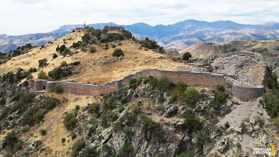
Smbataberd fortress is one of the best preserved Armenian fortresses
Smbataberd (fortress of Smbat) is one of the most popular hiking trails in Armenia! Except for hot July and August other months are “hiking friendly”. From Eghegis village, the trail will take you to the medieval Smbataberd (Fortress of Smbat). Then you can proceed towards the monastic complex Tsaghats Kar, which is approximately a 2-hour hike from Smbataberd. The trail ends near Zorats church...
More about Smbataberd – Tsaghats Kar – Zorats Church trail you can learn by reading this article!
Matosavank - Jukhtak Loop

Aerial photo of Matosavank
Matosavank - Jukhtak Loop, situated in Dilijan National Park, Tavush, is an easy 4.5 km trail. The path takes you to the 13th-century Jukhtak Monastery and then proceeds to Matosavank, another 13th-century monastery. The trail winds through dense forests, offering fresh air and a quick nature walk for those seeking a relaxing stroll.
Odzun-Hormayr-Kobayr trail

Aerial photo of Kobayr Monastery
The Odzun–Horomayr–Kobayr trail, spanning 9 kilometers through the breathtaking Debed Canyon, is widely regarded as one of Armenia's most picturesque hiking routes. Begin your journey with a visit to the remarkable Odzun Church, an architectural gem. From there, descend to the 12th-century Horomayr Monastery, nestled in the cliffs, and continue onward to the equally stunning 12th-century Kobayr Monastery, which marks the conclusion of this unforgettable trail.
Mount Yeranos Trail

View from the summit of mount Yeranos
Mount Yeranos (1823m) is a peak near the northern edge of Ararat Region, Armenia, in the western half of the Yeranos mountain range, 8 km northeast of Lanjazat village. From the summit a breathtaking view opens up towards Azat reservoir! The trail is radial and stretches 18 km.
Old Khot-Shinuhayr trail

Me exploring Old Khot village
Hiking along the Vorotan Gorge is another exciting trail I strongly recommend exploring in Armenia. Start your hike from Khot village, where the map of the trail stands, and descend to the old Khot village. This is an abandoned village often referred to as the Armenian Machu Picchu due to its resemblance to the Inca citadel located in the Eastern Cordillera of southern Peru. After exploring this ghost village, head towards Shinuhayr village, exploring more abandoned buildings along the way. For more about Old Khot check out this article!
Hiking tour to Lastiver

Here I am, standing by the cascades of the Khachaghbyur River
Nestled near the Khachaghbyur River, Lastiver boasts a two-story cave on a steep canyon slope, surrounded by towering trees, rugged cliffs, and a cascading waterfall that creates a magical ambiance. This historic refuge during the Mongol invasions of the 13th and 14th centuries owes its name to the log staircases resembling rafts that once provided access.
The site’s charm extends to whimsical huts perched on 'chicken legs' and bas-reliefs carved by Soviet sculptor Benik Petrosyan in the 1970s, often mistaken for ancient works. Today, Lastiver’s blend of history, art, and pristine nature makes it a sought-after destination for hikers and ecotourists alike.

In the 1970s, Soviet-Armenian sculptor Benik Petrosyan decorated the cave walls with expressive bas-reliefs, adding to its mysterious atmosphere. Many visitors assume these carvings are ancient, which only deepens the sense of wonder.
The linear trail at Lastiver extends for 7 kilometers and is classified as easy, making it accessible for hikers of various skill levels. It remains enjoyable in all seasons, offering a journey through dense forests and presenting breathtaking views of the surrounding natural beauty. For hiking tour to Lastiver follow this link!
Ready to Hike with Suren in Armenia? If this sparks your interest, let’s chat! Send me a message on WhatsApp or Telegram at +374 55677868 to plan your perfect hiking adventure in Armenia. Safe travels!
Gallery


You May Also Like
Grigor Khanjyan’s Monumental Fresco at the Yerevan Cascade

From Stendhal Syndrome to Suren Syndrome

Tirinkatar Sacred Valley: Armenia’s High-Altitude Valley of Dragon Stones

How to Choose a Local Guide in Armenia

Komitas Pantheon in Yerevan

Gallery of Mineral Waters in Jermuk

Shvanidzor’s 17th-Century Aqueduct: Armenia’s Ancient Engineering Marvel

Guide in Armenia
